


Discover Namibia and Explore its Fossil Record Dating Back to the Ediacaran Period
- Wayne Munday
- Oct 9, 2024
- 7 min read
Updated: Feb 23
Sip back and discover Namibia a unique destination to explore breath taking landscapes, experience a wildlife safari as well immerse yourself in a transformative fossil record. As one of the least densely populated countries in the world Namibia provides the opportunity to connect with a natural environment that dates back over 2.6 billion years including the fossils of the Nama Group of sedimentary rocks. Located in the southern ǁKharas and Hardap Regions these three dimensional casts, trace fossils and first skeletons date to the Ediacaran – Cambrian Transition between 550 - 538 million years ago and tell a story of gradual mass extinction of Ediacaran biota and the emergence of the oldest known multicellular animals exhibiting a behaviour of boring, burrowing, locomotion and feeding in advance of the Cambrian Explosion.

The Fossil Sites of Namibia
Before we explore the Nama Group of Southern Namibia and its relevance in unlocking the secrets of the Ediacaran – Cambrian Transition. Its interesting to know that Namibia has a number of other fossils sites from various geological ages.
The Omuramba Omambonde dinosaur track site of the Otjozondjupa Region of Namibia is a National Monument. Located on the Otjihaenamparero farm roughly 30Km from the settlement Kalkfeld it shows the isolated crossing tracks of over 350 three-toed and clawed dinosaur footprints, probably bipedal dinosaurs, from the Lower Jurassic Etjo Formation of aeolian sandstone.
In 2015, in the north-west of Namibia a new giant 2.5 meter (possibly longer) four-legged, salamander-like amphibian with interlocking fangs was discovered and named Gaiasia jennyae that dated back 280 years to the Permian Period. This large predator was discovered in the Gai-As Formation along with fossils of fish. They would have lived in a cold temperate lake which fits chronologically with what we will soon discover about the presence of fjords in Namibia.


From Left to Right
Image of Dinosaur footprint from Omuramba Omambonde dinosaur track site (Image by F Igy) | Middle : Depiction of Gaiasia jennyae (Image by Olmagon) | Right: 1995 National Stamp depicting Diamantornis wardi - Image by NamPost
The Micocene Epoch between 23 – 5 million years ago in Namibia saw the evolution of the now extinct Lower Miocene giant bird called Diamantornis wardi. This was an ancient relative to the Ostrich whose large fossil eggs were discovered in the sand dunes at Roilepel in the ǁKaras Region.
Namibia is also where the early Ostrich species known as Struthio daberasensis was discovered in the Late Miocene Andoni Formation on the Stinkwater Peninsula of the Etosha Pan. The Ostrich is generally believed to have first evolved in Africa but its fossil record across the Miocene, Pliocene and Pleistocene is complicated with several evolutionary transformations in both Africa and Eurasia.
An Era of Fossil Discovery
Following the early explorations of Africa by Livingstone, Savorgnan de Brazza, Hanning Speke and Barth all of whom identified a wealth of raw materials, minerals and people. Germany was one of 13 countries to start a claim for the colonisation of Africa. Known as the “Scramble for Africa” this was a dark time in the history where conflict and unrest continued between 1884 – 1915 as Namibia was annexed by Germany and renamed the German South West Africa. Until independence from Germany on the 9th July 1915 after 31 years of German rule the indigenous peoples and tribes of Namibia experience harsh colonial policies.
It was during this period of occupation that German government geologist Paul Range and occupying German soldiers became intrigued by the vague outlines and impressions in the rocks of Aus in southern Namibia.
The Nama Group
The Nama Group of fossiliferous rocks covers roughly 125,000 square kilometres and is located in the Nama Basin of southern and central Namibia including the ǁKharas and Hardap Regions. The Nama Basin was formed and flooded during the breakup of the supercontinent of Rodinia between the Precambrian "supereon" or Neoproterozoic until the early Cambrian Period some ~550 to 500 million years ago. This was a time when the Earth was at its most transformative in terms of the evolution of life.
At over 3,000 meters in depth it is sequence of interbedded shallow-water marine sediments of carbonate and siliciclastic rocks. These alternate sediments indicate that they were formed in an dynamic environment of changing shallow sea levels.
Within the Nama Basin there are three sub-basins known as the Zaris, Witput and Witvlei. These are smaller foreland basins that lay upon the compressional plate boundary between the Congo Craton to the north and Kalahari Craton to the south and adjacent to the Naukluft Mountains created by the pan-African Damara orogeny some 580 millions years ago.

These basins hold an impressive fossil record of trace fossils and the first early skeletons from the Ediacaran – Cambrian Transition dated at 550 - 538 million years ago indicating the emergence of the oldest known multicellular animals.
The Zaris Sub-Basin is known for the earliest recorded fossils of Cloudina, Namacalathus and Namapoikia were a among the earliest shell building animals to evolve a mineralised skeleton or shell either made from a series of small nested calcareous cones or a goblet shape.
The Witputs Sub-Basin is known for the occurrence of Corumbella a sea bed living organism that had developed an early external skeleton or calcareous carapace of thick overlapping polygonal plates. Also within this basin are several unique trace fossils to first show distinctive marks of bioturbation made by the active disruption of sediments by mobile organisms as they actively engineered their ecosystem to better access nutrients in the sediments by boring, burrowing, moving and feeding.
Exploring Namibia's Landscape
Namibia promotes responsible travel and links tourism with a commitment to conservation outcomes and is a leader in responsible tourism and has many eco-friendly destinations. Within this arid country there is a diverse number of natural landscapes to be explored alongside its fossil record.
Nearly half of Namibia's land is exposed bedrock while the remainder of the country is covered by surface sediments from both the Kalahari and Namib deserts. Namibia shares its borders with Angola in the North, Botswana in the east, South Africa in the South and its western coastal border with the Atlantic Ocean enigmatically known as the "Skeleton Coast".
Namibia is a country rich in minerals, gem stones and metals and has a well-developed mining industry especially for Uranium, Diamonds, Gold, Silver and the rare earth elements of Lithium, Nickel, Copper and Cobalt.
The Namibian Coast is over 1,500 kilometres in length and in some parts it can stretch inland up to 40 kilometres. This coastline includes the northerly 500 kilometre section of the Skeleton Coast National Park.
The Skeleton Coast is a rugged and challenging place strewn with the skeletons of whales and seals from a bygone era of whaling and seal hunts.The beaches are littered with an estimated 1,000 shipwrecks that have fallen foul of the treacherous seafaring conditions along this stretch of coastline created from a cold strong northwards flowing ocean current known as the Benguela Current.
This coastline combines the temperate winds of the desert with the cold surface water temperatures to produce a thick sea fog known locally as “cassimbo”. If fog was not enough for the ship's captain the combination of strong onshore winds, heavy swell and the risk of running aground on submerged rocks and shifting sand bars lives up to its description as “the land god made in anger”.

Interestingly, and somewhat paradoxically, the arid desert of the Kaokoland Region which neighbours the Skeleton Coast in the north west of Namibia is traditionally known for its typical arid desert landscape of huge plateaus and deep U-shaped valleys and ephemeral streams that flow after it rains.
However, recent research has interpreted this landscape as fossil fjords carved out around 300 million years ago during the Late Paleozoic Ice Age (LPIA), a period when Namibia was closer to the South Pole, the Earth’s climate was much colder and Gondwana was experiencing multiple episodes of glaciation. As the Earth warmed Namibia’s fjords slowly filled over the next 130 million years with sediments helping to preserve them.
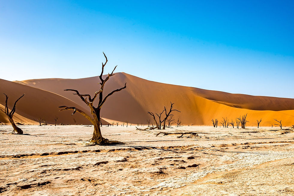
The Namib Desert is believed to be the world’s oldest desert and where the enormous and iconic red star sand dunes and white clay salt pan of Deadvlei meaning "dead marsh" of the Sossusvlei can be found.
As well as a rich geodiversity Namibia has a rich biodiversity adapted to a desert ecosystem. Namibia is home to elephants, rhinos, lions, and cheetahs and where tourists can experience a safari at the Etosha National Park one of Africa’s largest wildlife sanctuary's.
Only a short drive from the Von Lindequist Gate that enters the Etosha National Park is the town of Khorixas known for its Petrified Forest or rather a collection of large fossilised tree trunks dating back 280 million years. They are believed to have been washed downstream by an ancient river before being covered by sand and petrified.
Etosha loosely translates as “Great White Place” in the Oshiwambo dialect spoken by Namibians and refers to the Etosha Pan. This is a vast white mineral-rich clay salt pan and is both the largest in Africa and also covers over a quarter of the Etosha National Park. The Etosha Pan was once a great lake 100 million years ago and over time it has evaporated to leave a dry baked, high pH and high sodium white clay.
During periods rain the Etosha Pan forms large pools of rainwater that become oases for wildlife like the Black Rhinoceros, Springbok, Gemsbok, Zebra, Lion, Cheetah, and Hyenas as well as the breeding ground for the Lesser Flamingo’s between January and February. The Etosha Pan is also home to Storks, African Openbill, Great Crested Grebe and the Black Necked Grebe.
The Ediacaran–Cambrian Transition found within the Namibian fossil record is a great story to explore in the knowledge that it has contributed towards our understanding into the emergence, complexity and diversification Animals.
Before Travelling to Namibia
For more information why not consider a visit to the National Earth Science Museum in Windhoek its is just the place to explore more. For people travelling on a full “British Citizen” passport from the UK please follow UK government’s travel checklist to understand and advice before travelling to Namibia on the current rules for the most common types of travel.


